Earthquakes
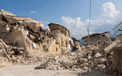
Earthquakes pose a danger to people, buildings and infrastructure worldwide. But what are the risks in Germany? How do I behave correctly in the event of an earthquake? And what else should I know? All of this and more can be found on this topic page.
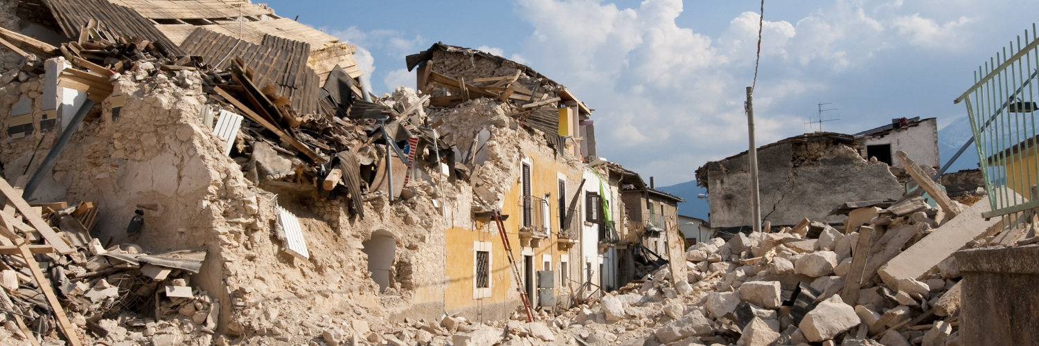
© pixabay
Earthquakes in Germany
Earthquakes pose a considerable risk to people, infrastructure and the environment worldwide. According to the Federal Institute for Geosciences and Natural Resources (BGR), a strong earthquake that can cause damage occurs on average every three days worldwide (BGR). In an international comparison, the risk of earthquakes in Germany is comparatively low due to its geographical location on the Eurasian plate at some distance from active plate boundaries. However, it is not negligible, as damaging earthquakes also occur in Germany at regular intervals. The last quake with significant damage in Germany occurred on April 13, 1992, with a magnitude of 5.9 on the Richter scale. More than 30 people were injured in North Rhine-Westphalia and the monetary damage in Germany was estimated at around 80 million euros (Geologischer Dienst NRW).
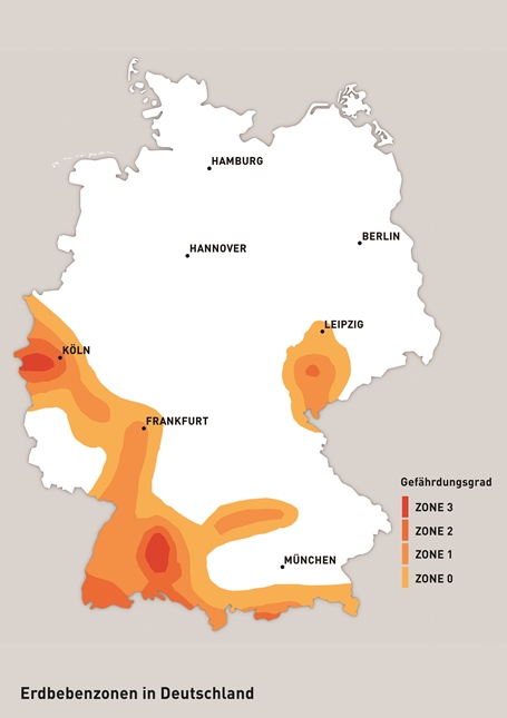
The institutional member of DKKV, the German Research Center for Geosciences in Potsdam (GFZ), published a study in 2018 to assess the risk of earthquakes in Germany. The risk areas in Germany primarily relate to the Lower Rhine Valley and the German Alpine regions. However, earthquakes also occur in the Thuringian Forest and the Swabian Alb. The map below from the website of the Federal Office of Civil Protection and Disaster Assistance (BBK) divides the earthquake risk into four levels.
Figure 1: Earthquake zones in Germany | Source: BBK
Definition and origin of earthquakes
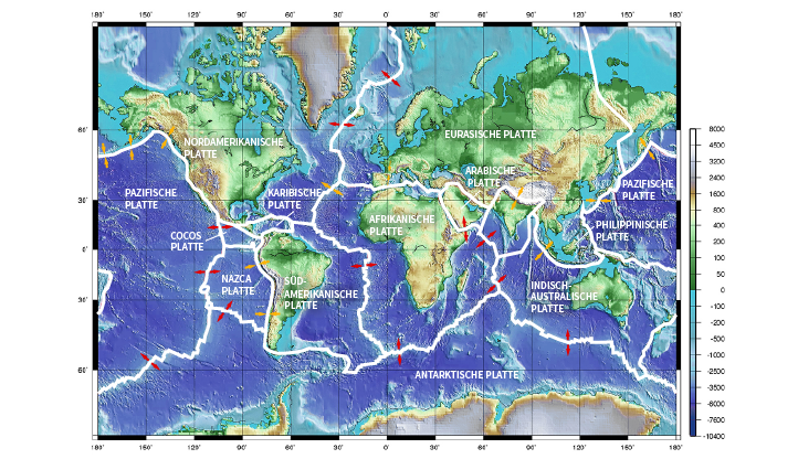
Earthquakes are generally understood to be large-scale tremors in the ground, which are usually caused by a sudden release of stress along fractures in the earth’s crust. Constant movement of the tectonic plates causes tension to build up in the underground layers of rock. This process can take centuries to millennia, while the release (= the earthquake) usually takes place in seconds to minutes. Over 90% of earthquakes worldwide occur in regions where tectonic plates are adjacent to each other, i.e. they have a tectonic origin (Munich RE). The earth’s crust consists of seven large tectonic plates and a large number of smaller ones, whose boundary zones can take on different shapes depending on the movement of the plates. In seismology, a distinction is therefore made between the following plate boundaries:
Converging boundaries
Converging plate boundaries move towards each other and form differently depending on the plate constellation. A distinction is made between oceanic and continental plates, resulting in three different plate constellations.
Ocean-continent convergence: When an oceanic and a continental plate meet, the oceanic plate sinks below the continental plate due to its higher density. Most of the Earth’s volcanoes occur in this so-called subduction zone (volcanic belt). Seismic activity is also greatly increased by subduction (e.g. subduction of the Pacific Plate off the west coast of the USA). The subduction zones are usually preceded by deep-sea trenches (e.g. Japan Deep Sea Trench).
Ocean-ocean convergence: When two oceanic plates collide, the older, cooler and therefore heavier plate submerges. This also leads to increased volcanic and seismic activity, which results in the formation of elongated volcanic island chains. Examples of such island arcs are Japan and the Philippines. These subduction zones are also preceded by deep-sea trenches. These are particularly narrow, deep and elongated, such as the Mariana Trench with a depth of 11,000 meters.
Continent-continent convergence: continental plates have the same density and are much lighter than the underlying mantle. As a result, when two continental plates collide, none of the plates submerge. The plates are strongly deformed and overlap, fold or stack up. This results in orogenesis (mountain building).
Divergent boundaries
Divergent plate boundaries are zones where tectonic plates move away from each other. In these areas, new mantle material is transported to the earth’s surface, which is pulled behind it by the diverging plates, creating a trench structure at the plate boundary. These trenches can have spreading rates ranging from a few millimetres to several meters per year. Examples of diverging plate boundaries can be found in Iceland, Africa and even in Germany with the Rhine valley trench.
Transform faults
Transform faults are characterized by the horizontal sliding of two plates past each other. They often, but not exclusively, occur on mid-ocean ridges. An example of a continental transform fault is the San Andreas Fault in California, USA. This runs over a length of around 1300 km and leads to an acute earthquake hazard in the region. The transform fault is located at the plate boundary of the North American Plate, which is moving southwards, and the Pacific Plate, which is moving northwards.
Figure 2: World map with plate boundaries (red arrows: divergent plate movement, orange arrows: convergent plate movement) | Source: ESKP 2020
Most earthquakes occur along convergence zones and transform faults. Many earthquakes occur under the ocean floor (seaquakes) and can trigger secondary hazards such as tsunamis (Springer). In addition to earthquakes caused by plate tectonics, there are other types of earthquakes, such as induced earthquakes or collapse earthquakes. Induced earthquakes are quakes caused by humans, for example by traffic or fracking. Collapse earthquakes often occur in karst areas and are caused by near-surface movements due to subrosion or salt leaching. However, compared to tectonically induced earthquakes, these are generally less intense and less widespread.
Excursus: Magnitude and intensity
The two scales magnitude and intensity are often confused when it comes to classifying earthquakes or earthquake shaking according to their strength. It is important to know the different meanings and implications of the scales in order to be able to interpret warning or media information.
Magnitude
The magnitude describes the total seismic vibration energy released during an earthquake. The so-called Richter scale, which is often mentioned in the media, was proposed by Prof. Richter in 1935. With the Richter scale, the magnitude is measured with a so-called seismograph and determined in detail from the logarithm of the maximum deflection of the seismograph and the distance to the earthquake source (GFZ). By specifying the magnitude on a logarithmic scale, the speed of the ground vibrations becomes ten times greater or smaller with a change in magnitude of 1. With a change in magnitude of +2, an earthquake therefore releases 1000 times more vibration energy (GFZ). There are now various magnitude scales whose values are calculated using different formulas. As the Richter magnitude cannot adequately represent larger earthquakes, the moment magnitude scale (Mw) is the most commonly used scale today. Nevertheless, the media often refer to a Richter scale, which is simply not correct. When the term magnitude (M) is used without a suffix, the moment magnitude is usually meant. The strongest earthquake measured since 1900 had a moment magnitude estimated at 9.4 to 9.6 (Chile 1960) (JGR Solid Earth).
Intensität
Unlike magnitude scales, intensity scales are not based on objective measurement data, but classify tremors according to human perception and the degree of damage caused. Earthquakes are usually divided into twelve classes from “not felt” to “total destruction”. The basis for this assessment in Europe is the European Macroseismic Scale (EMS-98). Epicentral intensity I0, on the other hand, is used when the observations take place directly above the epicenter (GFZ). In addition to this internationally used intensity scale from one to twelve, there are also some country-specific scales, such as the JMA Seismic Intensity Scale, which is used in Japan and Taiwan. This divides earthquakes into seven instead of twelve categories, with levels five and six being subdivided into “upper” and “lower” respectively. The JMA scale also uses subjective descriptions to classify earthquakes (JMA).
Damage and consequences of earthquakes
Reports often only mention the magnitude and not the intensity of an earthquake. However, magnitude alone does not provide any information about the actual damage potential of an earthquake. As a rule, stronger earthquakes also lead to higher damage and casualty figures, but there are also events that have caused only minor damage despite their high magnitude. The region in which an earthquake occurs is decisive. A strong earthquake in a sparsely populated region may be less devastating than a weak earthquake in a metropolitan region (Springer). Exposure and vulnerability are therefore more relevant to the severity of earthquake damage than the sheer strength of the earthquake.
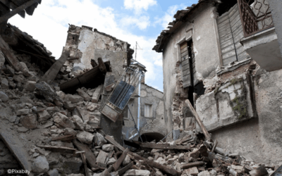
The direct danger posed by earthquakes is very low. “You can’t shake a person to death by an earthquake” (Erdbebendienst Bayern). The main danger comes from the consequences of an earthquake. Particularly in densely populated regions, the shaking causes major damage to buildings and infrastructure, which also results in personal injury. The reasons for this are often fires triggered by earthquakes and CBRN-Hazards. In addition, there are landslides and mudslides triggered by the ground shaking, as well as possible soil liquefaction (liquefaction). During liquefaction, loose sediments and groundwater are mixed by the earthquake, causing the soil to behave like quicksand. This soil liquefaction is only temporary, but very strong quakes can also cause permanent ground displacement, which can severely damage buildings in the affected areas (Erdbebendienst Bayern).
Another hazard is tidal waves, either in the form of tsunamis or from destroyed dams and dykes. Tsunamis are tidal waves that are usually caused by seaquakes, which result in the sudden displacement of large volumes of water. The resulting waves can reach wave heights of several tens of meters when they reach the coast. Tsunamis are considered one of the most destructive and deadly hazards resulting from earthquakes (Springer).
Earthquake Early Warning
According to current knowledge, it is not possible to reliably predict earthquakes because there are no reliable precursor phenomena (SWR). Earthquake early warnings, which are issued between the first seismically registered or weakly felt earthquakes, are therefore of great importance (ESKP).
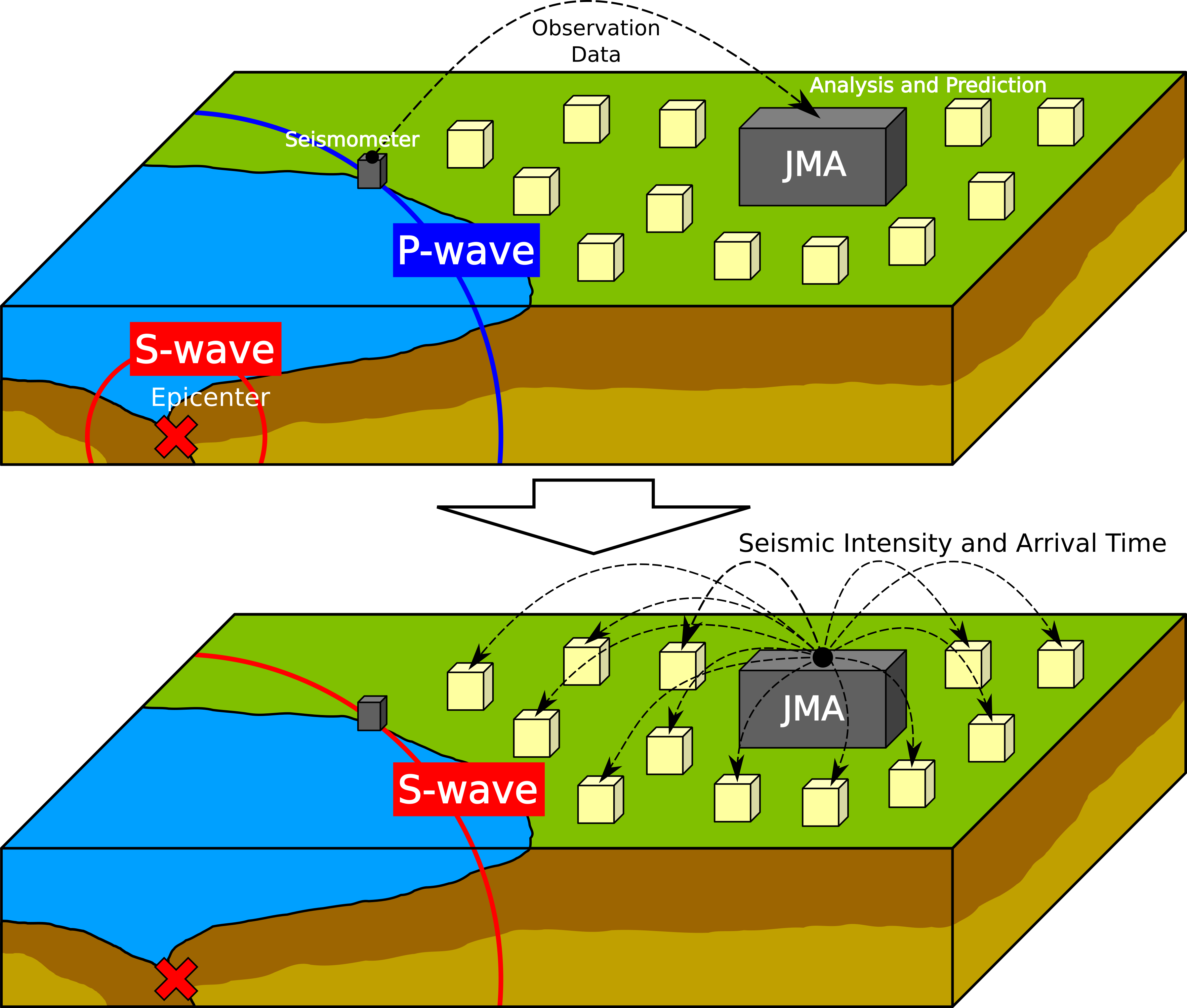
Earthquakes emit different types of waves, each with a different travel time: Primary waves (P-waves; propagation speed in the crust of around 6 km/s) and secondary waves (S-waves; propagation speed in the crust 3.6 km/s). If a harmless P-wave is registered by a seismometer, a warning can be given of the subsequent damaging S-waves via cable or radio (propagation speed of 300,000 km/s). In the case of dense seismometer networks, measurements in the immediate vicinity of the earthquake source provide a further small time advantage. The warning time depends on the distance to the earthquake source – this is usually only a few to tens of seconds. For this purpose, the signals are recorded by seismographs, sent electronically in real time to an evaluation center and converted into a warning message (FAZ).
Figure 3: Schematic representation of the earthquake warning process | Source: Antenese Geosurvey Indonesia
Recommendations for action in the event of earthquakes
In almost all countries with a relevant risk of earthquakes, building standards for earthquake-resistant design have been introduced under building law. In the Federal Republic of Germany, the first such standard for normal buildings was introduced in 1981. These building standards aim to protect people, but not to prevent damage altogether. In addition to these earthquake building standards for normal buildings, there are standards worldwide for the design of hydraulic structures, such as dams, against the effects of earthquakes, as well as standards for the structural safety verification of nuclear facilities, such as nuclear power plants (GFZ).
The following behavior is recommended by the BBK for private individuals before, during and after an earthquake:
Before the earthquake
- Secure furniture at risk of falling over using dowels or brackets
- Stairwells and corridors should be kept clear of furniture and other objects
- Keep heavy objects and glassware away from upper shelves
- Have emergency luggage ready in case you need to evacuate
- Find out about escape routes and emergency exits in advance
during the earthquake
- Stay inside the building and watch out for falling objects
- Keep away from windows, glass doors and other sources of splinters
- Seek shelter under door frames or tables
- Avoid elevators
- When outdoors, avoid the vicinity of buildings and look for an open area if possible
After the earthquake
- Think about aftershocks
- Leave the building, especially if you detect serious structural damage
- Supply lines (gas, water, electricity) should be turned off until they have been checked
- Help injured or buried persons – provide first aid
- In the event of injury, fire or water damage, call the fire department (112)
Emergency warning on the smartphone
NINA warning app
NINA warns of dangers such as flooding and other major emergencies throughout Germany and, if necessary, on a location-specific basis.
EQInfo
EQInfo provides worldwide earthquake information from various national and international earthquake services, including the GFZ’s GEOFON earthquake monitoring. However, a warning is not possible with this app.
LastQuake
LastQuake of the European-Mediterranean Seismological Center (EMSC) provides information about felt earthquakes and allows users to send reports about felt earthquakes.
Cell Broadcast
Since 2023, the Cell Broadcast System has also been used to warn of dangers, including earthquakes. The warnings are sent automatically to mobile devices. An additional app is not required.
additional links and information
more information
- Earthquakes – ESKP
- USGS Earthquake Animations for Terms and Concepts
Current Information
Earthquake in Afghanistan
During the night of 31 August to 1 September, an earthquake measuring 6.0 on the Richter scale shook north-eastern Afghanistan. The quake, which occurred at a depth of around eight kilometres, was followed by several aftershocks that reached magnitudes of up to 5.2,...
Earthquake in Turkey
A strong earthquake shook Turkey on Sunday evening. According to the Euro-Mediterranean Seismological Centre (EMSC), the quake had a magnitude of 6.0, while the Turkish Disaster and Emergency Management Authority (AFAD) reported a magnitude of 6.1. The epicentre was...
Created: May 2024


