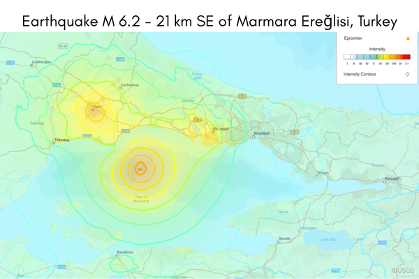
On April 23, 2025, at 12:49 p.m. local time (9:49 UTC), an earthquake of magnitude Mw 6.2 struck the central Marmara Sea, approximately 60 km west of Istanbul. Just 13 minutes later, a second quake with a magnitude of Mw 5.3 occurred south of the city. The hypocenter of the main earthquake was located at a depth of around 10 km – typical for shallow, surface-affecting tremors. According to GFZ (2025), it is the strongest earthquake in the region in more than 25 years. In Istanbul, numerous buildings were shaken, and at least 151 people were injured – mainly as a result of panic. No fatalities or major structural damages have been reported so far (Tagesschau, 2025).
The event occurred along the North Anatolian Fault Zone (NAFZ), one of the most significant continental transform fault systems on Earth, accommodating 23–24 mm of movement per year (USGS, 2025). This fault separates the Eurasian and Anatolian plates over a length of more than 1,000 km. The affected section in the Marmara Sea is a seismically active zone characterized by pronounced stress accumulation – especially in a so-called “seismic gap” south of Istanbul that has not experienced a major earthquake in over 250 years (Chen et al., 2025; USGS, 2025).
According to GFZ Potsdam, the rapid succession of the two quakes indicates stress redistribution along the active fault segment, potentially increasing the likelihood of further seismic activity in the region – particularly closer to the densely populated city of Istanbul. Current geophysical models do not rule out the possibility of a stronger earthquake of up to Mw 7.4. Such an event could have severe consequences for Istanbul, a megacity home to over 16 million people (GFZ, 2025).
As part of the GONAF project, GFZ is working closely with Turkey’s Disaster and Emergency Management Authority (AFAD). A borehole-based seismic observatory in the eastern Marmara region provides real-time data to assess stress changes and improve early warning systems for Istanbul. Ongoing scientific analysis of this data is crucial to developing realistic hazard models and evidence-based disaster preparedness strategies. The situation is currently being monitored intensively (GFZ, 2025).
As of April 24, 2025, 3:00 p.m. CEST
Chen, X., Martínez‐Garzón, P., Kwiatek, G., Ben‐Zion, Y., Bohnhoff, M. & F. Cotton (2025) Rupture Directivity of Moderate Earthquakes Along the Main Marmara Fault Suggests Larger Ground Motion Towards Istanbul. Geophys. Res. Lett., 52, e2024GL111460.
https://doi.org/10.1029/2024GL111460
Helmholtz-Zentrum für Geoforschung GFZ (2025): Erdbeben der Stärke 6.2 und 5.3 bei Istanbul. Retrieved 24/04/2025 under: https://www.gfz.de/presse/meldungen/detailansicht/erdbeben-der-staerke-62-und-53-bei-istanbul
Tagesschau (2025): Erdbeben erschüttert Istanbul. Retrieved 24/04/2025 under: https://www.tagesschau.de/ausland/asien/tuerkei-erdbeben-176.html
United States Geological Survey USGS (2025): M 6.2 – 21 km SE of Marmara Ereğlisi, Turkey. Regional Information. Tectonic Summary. Retrieved 24/04/2025 under: https://earthquake.usgs.gov/earthquakes/eventpage/us7000pufs/region-info
(Image Source: USGS)